Brief history of the Barangay
The first inhabitants of Sulipat were the Subanens. One of the native is a man named Lumangkay Sumaway. He is a respected leader of the area and had named the barangay “Sulipat”
Lumangkay Sumaway christened Sulipat on the basis of the two creeks in the area that form a letter S and the source of the aforementioned creeks. They were unknown in the area along with the bigger creek on the East, which was named “Sulipat Daku” and the area along the smaller creek on the west, which was named “Sulipat Gamay” upon survey and verification. The source of water of both creek runs to Langaran River.
Years later, a certain Antonia Mulit Ones (Tuyang) initiated a move to change “Sulipat” to Rizal with unknown reason but to no avail. The residents of the area were against the proposition due to its real meaning basing on the two (2) creeks forming letter S and due to their respect and in honor of Lumangkay Sumaway as its founder and respected leader in the past.
Geographical Location
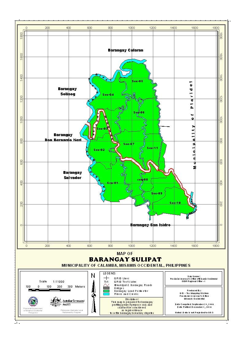
Barangay Sulipat of Calamba, Misamis Occidental is geographically located in the eastern part of the Municipality of Calamba, along the National Highway leading from Oroquieta City “Mountain Road” Calamba. It is approximately 6 kilometers away from the poblacion. It has estimated land area of 11,7268938 sq.kms., the biggest barangay in the municipality in terms of land area.
Political Subdivision
This barangay consist of 4 puroks, namely Purok I, Purok II, Purok III and Purok IV and has two sitios. Sitio Burgos and Sitio Socio.
The Barangay Captains since 1915 up to present:
- Lumangkay Sumaway
- Donato Florida
- Olimpia Corpus
- Diosdado Sale
- Vicente Malayao
- Victorino Gapol
- Sixto Lico
- Primo Tatad
- Zacarias Matunog
- Miguel Lata
- Cosme Engoc
- Julian Tatad
- Danny Engoc
- Reynaldo Gapol
Land Area
The total land area of Barangay Sulipat is 11,7268938 sq.kms. for agricultural land uses and residential uses.
Topography and Land Classification
Sulipat has high elevation and its area is mostly rolling. It has slope areas, which is about 8-10%. Most of the area is cocoland and some parts are planted with corn, bananas and vegetables. The barangay estimated elevation above sea level is ranging from 100-350 meters.
Soil Types
The barangay has soil type of Guimbaloan Clay and Clay Loam. The whole portions of this clay are grown with coconuts, corns, root crops, fruit trees and vegetables.
Climate and Rainfall
Rainy seasons falls on the months of September to December until January. Dry season is from February to March and April. Rainfall average is 18 cms. It is a typhoon free place. Temperature during dry season is fairly warm and on rainy seasons also the whole barangay is noted to be cool. Humidity varies between 75% per month. The winds from August and September go in Eastern direction while winds also from October to December and July has southwest monsoon conditions.
General Land Uses
About 91% of the total land area is an agricultural land. Only 7% is build up areas such as sites of barangay government buildings and other government structures and other residential lots. The other 2% are utilized also for some other purposes.
General Land Uses | Area In Hectares | Percentage |
| Agricultural Lands | 116.409 | 9.92% |
| Grasslands/Shrub Lands | ||
| Forestlands | ||
| Wetlands | ||
Miscellaneous Land Uses
| 8.60 | 90.08% |
Total | 1,128 | 100% |
- Details
- Hits: 17074


